On the secrets of Ben Scurrival - Beinn Sgurabhal, publ. on the 09/08/2026
Written and published by Linden Alexander Pentecost, published on the 9th of August 2026, and completed on the 10th of August 2026 at 2 am, UK time. This article is unrelated to and separate from any and all of my other publications, that includes other publications in which other aspects of, or things related to, the things discussed here, are discussed. I also took the two photos included in this article. This article covers a number of other interesting connected points not indicated within the title, for example, things connected to Tiree and Lewis, and to much more, which I have not discussed elsewhere. This article contains 2865 words. This article was published in the UK and no AI was used in this article or in any of my written works.
On the northern part of the Isle of Barra, An t-Eilean Bharraigh, rises the mountain of Ben Scurrival or Beinn Sgurabhal in Gaelic. I have discussed the etymology of this name in other publications, and it is somewhat uncertain, although the second element of the name Scurrival/Sgurabhal, i.e. the -val/-bhal element is cognate to the Icelandic word fell, Northern English fell, Norwegian fjell etc, all meaning "mountain".
Ben Scurrival is located close to the beach of Tràigh Eais meaning "Beach of the Waterfall". On some maps, such as the Sound of Barra map (1861-1862 Admiralty Chart 2770), Tràigh Eais is named as West Strand. I do not know whether or not "West Strand" was a later name applied to the beach after the widespread arrival of the English language to Barra, or if West Strand was a known name for the beach of Norse origin, used alongside the name Tràigh Eais in certain contexts. The map in question also shows how Tràigh Mhòr, the beach located on the other side of the sandbar and dunes to Tràigh Eais, used to almost connect to Tràigh Eais through a channel in the sound dunes, at the southern end of both beaches. In the present day this channel no longer (to my knowledge) becomes flooded, but I am not sure. In other, unrelated publications, I discuss a mysterious dream I had about this beach, where I saw the beach as though the dunes had not yet developed.
This part of Barra is extremely mysterious. Elsewhere I have published about and covered the dream I mentioned, and have also published about stories that connect the village of Eoligarry to the tale of a Norse princess, and the legends that connect the nearby Isle of Fuday/Fùideigh to the "last Norse in the Hebrides", and have discussed/published about the runic inscription at Cille Bharra, which today has sadly been replaced by a crude fibreglass copy, the last time I saw it it was covered in bird droppings. The people of Barra have requested that Edinburgh museum return the real runestone to Barra, but sadly this has not yet happened.
As well as the Norse and obvious Gaelic connections to the area around Eoligarry/Eòlaigearraidh, there are still further mysteries connected to this part of Barra, one mystery in particular concerns the cave of Uamh An Dùin, a seacave located above the Atlantic Ocean and on the side of Ben Scurrival. A brief introduction to this mystery can be found in one of my articles published on a different website, titled: More on the Jura Gaelic dialects, ancient Jura & connected topics, published on the 11/04/2026.
There is to my knowledge no confirmed evidence of Mesolithic visitors or settlers in the Outer Hebrides. This is not the case in the Inner Hebrides, the difference does I think relate in some way to differences in how the Inner and Outer Hebrides changed position in relation differently in relation to sea level. The Outer Hebrides must have experienced higher sea levels in the past. But, in the Outer Hebrides, the trend since the Mesolithic has been that the land has fallen in relation to the sea, which is why there were once areas of land to the west of Barra and South Uist which are now submerged. I discuss many other aspects to this in detail elsewhere, including the way in which the Storegga tsunami could have seriously impacted those ancient lands that were once to the west of Barra and South Uist.
Of the brochs and duns on Barra and South Uist, to my knowledge, they are mainly orientated on the west coasts of these islands. This is not necessarily significant, but it is also noteworthy that most of the brochs on Lewis (but not the duns) are located on the west coast of Lewis. It is curious that in the Outer Hebrides these structures are often orientated towards the Atlantic and the Americas, rather than towards the mainland, especially considering that these structures are described as defensive - although I do not agree with this, or certainly don't think that that was the primary purpose of brochs - not originally.
The lack of Mesolithic evidence in the Outer Hebrides could be because Mesolithic people were there, but that their sites, being often coastal, are now beneath the waves. I have discussed a lot more on this elsewhere and how it may pertain to dialectal variations within Outer Hebrides Gaelic. I have also discussed many times before a possible connection between the broch builders (i.e. their original builders), and Mesolithic peoples. One aspect of this concerns the ciuthach, a kind of hairy giant in Gaelic folklore, said to have been known on Barra. They were also known on Lewis, and are associated with brochs there, but are also associated with living in caves, and with having boats of a prehistoric form. In my opinion, other things also imply specific connections between these things.
It is commonly presumed that by the Iron Age, the tribes present in Scotland from the Mesolithic would have become extinct or been replaced. But this is not necessarily the case. The Mesolithic populations were small anyway, so if they did survive, it may well "appear" to us that they weren't there, simply because they were so small in size in relation to other peoples. There is in my opinion plenty of suggestion however that these cultures, in some way, survived into relatively recent times. They may not have continued as entirely separate cultures, but may instead have existed as particular expressions of lifestyle and belief, with their own variations in language, among other Gaels; although it is also I think the case that some of their languages did survive completely into more recent times, and one of them I think survives to this day: Beurla Reagaird; although I do not think the people I am discussing in this article as the same as the Indigenous Highland Travellers and their ancestors.
And this leads back to Ben Scurrival and to the cave of Uamh An Dùin. The Mesolithic people, or rather, some groups of them, made use of sea caves in Western Scotland, and it would appear that they ate quite a lot of shellfish. There is also something rather strange about Uamh An Dùin that doesn't quite make sense to me. It is a sea cave, but it is located a fair distance above the sea, and a cliff in front of the cave rises up from the sea. Even though Barra has had a tendency to fall in relation to sea level, the sea level must surely have been significantly higher at some point in the past, in order to create this cave. The question is, how long ago? In the next section after the photo description & photo below I will discuss more on Uamh An Dùin.
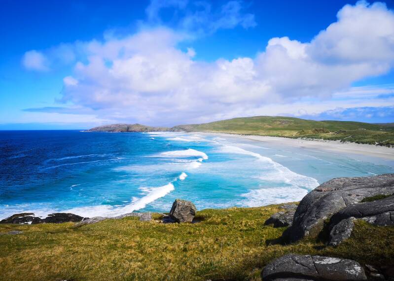
Photo below: the beautiful, otherworldly and heavenly beach of Tràigh Eais or West Strand on the Isle of Barra, with Ben Scurrival/Beinn Sgurabhal being the mountain visible in the distance, slightly to the left o the image centre, being the headland in the distance that overlooks the Atlantic. The rock in the foreground, centre image, "could" potentially have been thrown there by wave action during extreme ocean surges, as there are several other large rocks located nearby. This beach is to me one of the most mystical, heavenly and beautiful places on earth, and the photo below, with the seas and incredible skies, helps to show why. During the past, the sea would have been to the west of here (further to the left of the image), and much of what is now sea would have been land.
Whilst no evidence has been found (yet, anyway) of Mesolithic people having used Uamh An Dùin, I do think that there is much more research to do here, because there are indicators at Uamh An Dùin and at Dun Scurrival of cultural similarities with Mesolithic peoples. Firstly, Uamh An Dùin was occupied in the past, and, considering that a skull was also found there, the cave may have had more spiritual and other culturally significant aspects as well.
According to information on the her.cne-siar.gov.uk website, concerning site number 833, which refers to Uamh An Dùin, a human skull was found in the cave itself, which I think could perhaps indicate pre-Christian beliefs, but this is not confirmed. I have discussed elsewhere MacLean's Skull, a skull hundreds of years old, placed into a cave on Jura, and how this seems very pagan and animistic, and the presence of Mesolithic people on Jura, and cave use in the Mesolithic, e.g. on the Isle of Ulva and at some of the coastal caves near Oban. So, in terms of the general themes of living in caves and the evidence of a skull, this does I think imply the possibility that the people using Uamh An Dùin during the Medieval period (as pottery was found at the cave from this period, and from earlier), might have had some links to more ancient cultures in Scotland. Because both Medieval and earlier pottery was found at the site, this may indicate continuity, even if the cave's only survived in a symbolic way, visited and known by certain groups in the Middle Ages.
These people present at the site during the Middle Ages, could have been connected through continuity also to the Iron Age builders of the dun of Dun Scurrival/Dùn Sgurabhal. On the her.cne-siar.gov.uk website page for Uamh An Dùin it is said that "sheel debris" were found there, which I think is "shell debris", and in the text it is implied that shells were found there. If this was the case, as I previously presumed when I wrote briefly about this elsewhere - then it is curious, because shell debris are also found at Mesolithic sites, and sometimes at the much later Iron Age broch and dun sites, so it would seem. According to the page on the her.cne-siar.gov.uk page for Dun Scurrival, which is given the number 518 - a shell midden with pottery was also found at Dun Scurrival.
Essentially, I think that the usage of the cave in a Medieval and earlier context, the presence of an ancient skull within it, the shell debris, possibly at the cave and definitely at the dun, the previous connections I have made between these things, and the proximity of this cave to the sea and to where land would have been in the Mesolithic - are not conclusive of anything; but I have a feeling that they do indicate and imply that there is something significant about this story that we have still to find, and I feel that it will take a lot of research.
The thing about shell middens and deposits is I think significant, because archaeological evidence suggests that eating shellfish in relatively large amounts was not uniform throughout the coastal communities of the prehistoric Hebrides, rather it seems to have depended. The peoples present at at Cladh Hallan on South Uist for example seem to have lived a much more dairy, and generally agriculture-based lifestyle, even if at the time the sea was likely further to the west, at least to some degree. More text continues after the photo and photo description below:
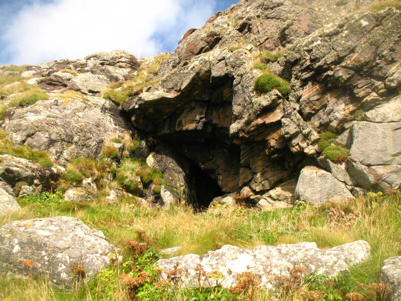
Photo below: the entrance of Uamh An Dùin located not far beneath Dun Scurrival. The cave has an impressive entrance, but is quite dangerous to reach. In Mesolithic times it would have commanded a view over the landscape, towards the sea an unknown distance away. Today, the cave stands above the churning waters of the Atlantic.
The themes of this article's content in many ways relate to the legends from Barra about the mystical island of Rocabarraigh, and about the Clach Mhór nan Gleannan on Barra, a large boulder; I have discussed the aforementioned connections in a lot of detail elsewhere.
There is also a legend about a cave on Barra known as Uamh an Òir, "The Cave of Gold". According to: On the Verge of Loss: Lesser Known Place-names of Barra and Vatersay by Anke-Beate Stahl, a piper became lost in this cave, and his dog returned from it, but hairless. A very similar legend exists on the Isle of Tiree, regarding a cave at Kenavara/Ceann A' Bharra, the cave in question also known as Uamh an Òir. According to the page: An Uamh Mhòr or Uamh an Fhuamaire or Uamh Dhiarmaid or Uamh an Òir or Uamh nan Calman, on the tireeplacenames.org website. The legend here is similar, implying a piper went into the cave and was never seen again, but his dog returned, hairless. Another cave close to this on Tiree is known as Uaimh an Fhoimheir - "The Cave of the Giant", which is interesting, given that a ciuthach is also associated with Kenavara, which I have discussed elsewhere, This is according to the article: Ciuthach, by William J. Watson, published in: The Celtic Review, Vol. 9. Note the connection with the ciuthach to these topics that I mentioned earlier. Furthermore, as I discussed in another of my articles on this website, there is a witch associated with Kenavara on Tiree, which leads to the subject of witches and their connections with prehistory. As I discussed in some books I wrote and in other places, a "Green Lady" is also associated with Kenavara on Tiree. If there is anywhere on Tiree which would seem to have the most potent memories and spiritual connections to the ancients, I would guess it could be Kenavara. And these forces are still believed in by some of the older folk on the island, and these forces are I think to be respected, especially given the implication that these "Caves of Gold", on Tiree and Barra, are dangerous and should not be entered. Furthermore, the chasms and cliffs around Kenavara, the chasms which can be 30 feet deep or more and appear suddenly, make exploring the caves in this area extremely dangerous. Note the fact that the specific cave at Kenavara referred to as The Cave of Gold, is also known as Uamh Dhiarmaid, is likely named in relation to the most common legend about the ciuthach. I have written also about my own trips to this headland for many years. See also for example my article published a few months on a different website, the link to the aforementioned article is: https://www.clwaideac-na-cuinne.co.uk/other-articles-related-to-archaeology-spirituality-and-other-topics-j1-j5/j1-more-tiree-flints-mystical-landscapes-more-on-polyamory-the-attecotti-publ-on-18-06-2026 .
Another thing I would like to discuss briefly in this article is the presence of possible propped stone structures, found on the island of Beàrnaraigh Mór or Great Bernera off the western coast of Lewis. These are documented on the megalithic.co.uk website, which shows 6 propped stone sites in the northwestern part of the island; note again my comments earlier in this article about western or Atlantic orientated sites. An impressive example is the Carnan Gibegeo Propped Stone CG2, another is named the Stiogha Chnap Propped Stone SC1. I have discussed these sites in many places elsewhere, but will briefly say here that they seem to be found all over the Northern Hemisphere, including in the Americas, in Cumbria, for example (see another of my articles on a different website, the link to which is: https://www.clwaideac-na-cuinne.co.uk/articles-about-spirituality-language-m1-to-m18/m2-an-example-of-a-propped-stone-in-northern-england-related-linguistic-points-other-points ) - also in Northern Scandinavia and Northwestern Russia for example. I have discussed and published about, having visited, many many examples of them. I hope soon to possibly have an article published elsewhere, which will relate to Tiree Gaelic, and wherein I may also discuss another example of a possible propped stone on the island of Coll. These sites are really interesting, because even though they display megalithic architecture, they seem to exist outside of the megalithic cultural identities and zones that are associated with agriculture and with megalithic sites in Europe more generally. Many examples of propped stones occur around the mountain of Vottovaara in Karelia for example, an area not connected to agricultural cultures in prehistoric times. So are these propped stones something older; and do they in some way relate to the ancient cultures of the western Outer Hebrides?
I hope that this article spikes the curiosity in folk. It is dedicated to the ancestors of the Hebrides and to the people of the Hebrides, and to all those who find something spiritual there.