On archaeological features near Dùn Chuithir & related topics, published on the 07/04/2026
This article was written and published by Linden Alexander Pentecost and was published on the 7th of April 2026, the photos were also taken by myself the author. This article and all of its content including its photos are unrelated to and separate from my other publications concerning Barra and related topics. This article was published in the UK and on this UK website, no AI was used nor is it used in any of my written publications. This article contains 1891 words and seven photos.
Dun Cuier or in Gaelic Dùn Chuithir is a structure variously described as a "broch" or "dun" located close to the settlements of Cuier/Cuithir and Allasdale/Allathasdal on the western side of the Isle of Barra. Located around Dùn Chuithir are various archaeological features in addition to the main broch structure, - the purpose of these other structures I am unsure of, but many look like field systems, one was a horse coralle, at least in later times, and there are other features too, a clearance, or other cairn, as well as areas of wallking and large stones, some of the large stones may have had significance or may have been positioned by people, but at this point it is difficult to say. Dùn Chuithir proves that this rocky hilltop was used by people in the Iron Age, but it would of course have also been significant to the Bronze Age and Neolithic peoples on Barra too, and we know that there was also Iron Age and Bronze Age activity at Allasdale/Allathasdal a short distance away. The Bronze Age people at Allasdale/Allathasdal are attested from sites in the dunes of Allasdale/Allathasdal, but at the time, sea levels would have been lower, and their landscape would have been an agricultural one, and one can easily imagine that this agricultural landscape could have extended into the upper parts of the valley of Allasdale/Allathasdal and how the site upon which sits Dùn Chuithir could have been important to them, although I am inclined to think that the Iron Age builders of Dùn Chuithir were not the exact same culture as that that existed at Allasdale/Allathasdal itself in the Bronze and Iron Ages. Note that I have published a lot of other things about different aspects of Barra's language, Gaelic dialect and ancient languages and history elsewhere, and elsewhere on this website I discuss the Pabbay Pictish symbol stone and other topics, this symbol stone being located on Pabbay not far from Barra; the aforementioned article can be read by following the following link https://www.kielimatka-2-11.co.uk/b1-more-on-barra-isles-language-on-the-pabbay-pictish-symbol-stone-published-on-the-15-03-2026 . I have also discussed much more on Barra's Gaelic dialect, ancient language, Norse and other features like archaeology, folklore and history on other websites, in many articles, as well as discussing many different aspects to this across many different books.
There are a large number of archaeological sites on Barra and Vatersay, some of which I have discussed elsewhere, and there are doubtless many other archaeological features which have not yet been discovered. The people indigenous to Barra and to the Outer Hebrides in general have a lot of respect for their ancient history, and the same can not always be said for the archaeologists and visitors who come to these sites and who seem them merely as "data", and not as living, spiritual places, connected to the people of the islands across thousands of years. Another curious site which I recently became aware of is known as Clach Mhór nan Gleannan or "Big stone of the Glens", a large boulder located not far from Tràigh Mhór where the airport is. There is a local legend that if Clach Mhór nan Gleannan ever rolls into the sea, then Barra will be doomed, this is recorded in the article: On the Verge of Loss: Lesser Known Place-names of Barra and Vatersay by Anke-Beate Stahl. I personally wonder if this boulder and its legend connect in some way to the legends of Rocabarraigh and to the ancient sinking of a part of Tiree/Tiriodh, which I have discussed many times elsewhere, there being a legend about the mysterious island of Rocabarraigh that should it appear a third time, it will be the end of the world. The legend associated with Clach Mhór nan Gleannan seems perhaps connected to this in some way. Note I also discuss other aspects that connect to Rocabarraigh in the article linked to in the previous paragraph.
There were also Neolithic people on Barra of course, and Allasdale is not far from Dùn Bharpa, a Neolithic chambered tomb south and slightly east of Dùn Chuithir and located high in the mountains. In my own judgement, the Neolithic chambered tomb of Dùn Bharpa is most likely connected to the broch builders of Dùn Chuithir and/or perhaps to the Bronze Age and Iron Age peoples of lower Allasdale/Allathasdal in some way. It is interesting that the Neolithic chambered tomb of Dùn Bharpa is situated high in the mountains, and not far from another chambered cairn, also likely Neolithic, known as Balnacraig - a tomb which I may have come across accidentally once, when walking in the mountains of Barra, but I am not sure, it was back in 2011. This seems to suggest that some of the indigenous groups in Barra may have had a specific reason for building chambered tombs in the mountains, although it is also possible that coastal examples existed, which are now flooded by the sea. In the photo descriptions above the photos below, I describe and discuss some of the various archaeological features on the hill where Dùn Chuithir is situated, although I do not discuss Dùn Chuithir itself. I have discussed Dùn Chuithir itself in other publications however, including in my book titled: More on Britain's linguistic past, and prehistoric, runic, slate and copper mine related and other aspects primarily to Western Britain and connected topics, this pdf-only book is published via clwaideac-na-cuinne in the UK on the 17/09/2025, which can be bought from the following link on another of my websites (not the website you are currently on): https://www.clwaideac-na-cuinne.co.uk/buy-pdf-books-published-only-via-this-uk-website-but-separate-from-this-uk-website-s-online-content . Below are the photo descriptions in italics and the photos:
Photo below: an embankment structure that looks more substantial than a typical wall on Barra. This is not linear but meanders its way towards the rocky crag upon which is situated Dùn Chuithir. This to me looks like it could be a prehistoric feature, although I am unsure about its precise purpose.

Photo below another structure, possibly as part of a field system, close to where the photo above was taken. Some of the rocks of this wall-like structure are of quite significant size, and as can be seen, along the wall there is a kind of cairn-like structure, which could simply be a clearance cairn but which could also have had other significance.

Photo below, another structure roughtly south of Dùn Chuithir, like the features shown in the two photos above, which may be slightly southwest of Dùn Chuithir. The structure below has been described to me as a horse corral, although I do not know if this was its original purpose or not, or precisely how old it is.

Photo below: a somewhat megalithic stone in a rather strange position which overlooks the valley of Allasdale/Allathasdal. Could this be an erratic, with the walled structure to the right later built into it, or could this larger rock to the left of the crag have been placed there? What is also curious is that this rock is very visible and prominent when viewed from near the structures below it, visible in the photos above. The wall could be a later feature, but I think it far more likely that it is at least Iron Age. Note the views towards the coastline and the greenness of the scenery. It is my impression also that the larger stone was placed there as a part of the structure, or was at least moved somewhat to be upon the wall, which is visible in the photo below the photo below. Again I think the sky is beautiful in the photo below.

Photo below: another view of the wall structure shown from a different angle in the photo above, with the larger rock clearly visible in the photo below. Note how this large rock seems to have been in part placed upon the wall structure. Whilst this does not prove that the rock was moved there, it may be indicative of this, and in which case I think that this rock and wall could be specifically aligning with some of the bank and wall structures to the south of it, although the purpose of this I am unsure of. Note also the sky in the distance, and the way that a layer of sea mist gives the impression of being a second strongly blue "sea" above the sea, above which the more light-coloured horizon goes into the distance, with the sky gradually darkening through shades of almost pink, purple, light green and blue above it. What a beautiful sky.

Photo below: another section of walling on the crag where Dun Chuithir is situated. Note again a large rock lower down the wall, and the way in which the wall has been carefully built up to the dangerous edges of the crag. The view over Allasdale/Allathasdal is again spectacular, and the lower part of the valley, close to the coastline, i.e. where Bronze Age and Iron Age discoveries were made, can be seen close to the sea. In the past, the land would have gone out further than here, although the greenness of the landscape, the blueness of the sky, and the clouds from the sea, would have been much the same as they are shown below.
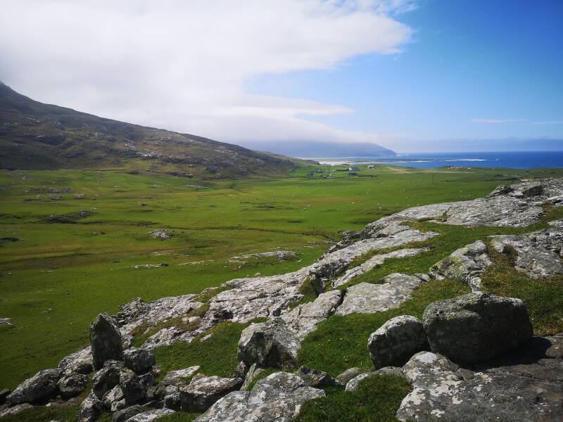
Photo below: another large, curiously placed rock not far from Dùn Chuithir. Tthis rock also gives the impression of having some significance, and I wonder whether or not it might have been positioned there, rather than being a purely natural erratic. The shape of the stone is also curious, and in some ways its shape is a little like that of a bird, although I cannot say for sure whether or not the shape of this rock has significance, but perhaps it does. What do you think?

I hope that this article was an interesting read, and I will publish about still other archaeological sites on Barra in the future which I have not previously discussed. The Highland Clearances were an awful thing and have also been an awful thing to the heritage of these islands, for example, because oftentimes I find that Hebridean blackhouses (of which some are closeby to the sites discussed in this article) are located close to ancient settlements, and often it seems there has been a continuity of culture, language and knowledge for a very long time, and the Highland Clearances have also meant that much of the information about the folklore, sacred sites and archaeological continuity of this island is incomplete - which is not to say that it is not retrievable. I also ask kindly that those visiting Barra and this site are respectful towards it and towards the ancestors that watch over these places. This article is dedicated to those ancestors and to my family.